Vocabulary
Understand and be able to apply each of these terms.
1. Biome: similar climatic conditions on the earth such as plants, animals and soil organisms
2. Climate: affected by latitude, terrain and altitude.
3. Rain shadow: a dry area on the leeward of a mountainous area
4. Windward: the direction upwind from a point of reference
5. Leeward: the direction downwind from the point of reference.
6. Latitude: a geographic coordinate that specifies the north south position of a point on the earth
7. Altitude: commonly defined as the height above sea level of a location
8. Primary Succession: the gradual growth of an ecosystem over a longer period
9. Secondary Succession: a process started by an event that reduces an already established ecosystem to smaller population of species
10. Tropical: warm to hot and moist year round, often with the sense of lush vegetation.
11. Temperate: lie between the tropics and the polar regions, relatively moderate than too hot or cold
l2. Desert: area that experiences a climate less that 250mm per year of precipitation and in some years may experience no precipitation at all.
13. Polar: an area that receive less intensive solar radiation
Critical Thinking
Read, analyze, and give complete answers to these questions.
1. Describe the rain shadow effect and explain how it can alter the climate of the windward and leeward
sides of a mountain range.
It blocks the passage of rain producing weather and creates dryness behind them.
2. What effect does living near a large ocean or lake have on average air temperatures? Why?- Explain.
Oceans provide a high level precipitation often results snowfall, but the average air temp. around ocean is going to be relatively cool.
3. Complete this summary chart of the land-based ecosystems.
4. For each category of biomes, give a major human impact and list 2 endangered species:
a. Deserts – Global Warming; Bald Eagle, Haliaeetus leucocephalus
b. Grasslands –Excess farming; California condor, panda
c. Forests –Deforestation; Red-cockaded woodpecker, Northern spotted owl
d. Mountains – Canada Lynx, Black-Footed Ferret
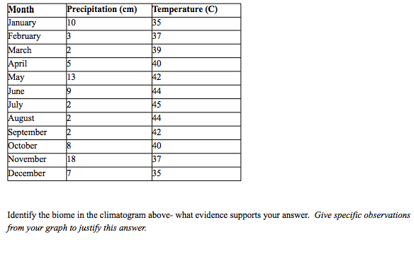
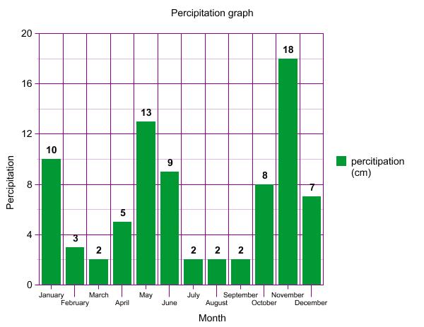
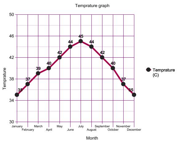
Climatograph
Use the data provided to construct a climatograph. Remember: Temperature should be displayed as a line
graph and precipitation as a bar graph.
a. Deserts – Global Warming; Bald Eagle, Haliaeetus leucocephalus
b. Grasslands –Excess farming; California condor, panda
c. Forests –Deforestation; Red-cockaded woodpecker, Northern spotted owl
d. Mountains – Canada Lynx, Black-Footed Ferret
Climatograph
Use the data provided to construct a climatograph. Remember: Temperature should be displayed as a line
graph and precipitation as a bar graph.